OFFICIAL
DESCRIPTION CHANGE
OFFICE:
Transportation Data
EFFECTIVE DATE: 07-01-2003
ENTERED
BY: Darlene Bovee
ENTERED
DATE: 07-31-2008
Due to a review of our Primary Road System Records
of Iowa 965 in
New Description –
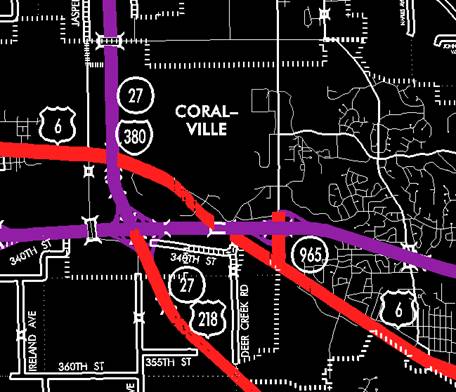
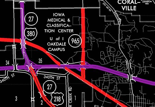
Coralville:
Beginning on Coral Ridge Avenue at a junction with
US 6; thence north on Coral Ridge Avenue to the north ramp of Interstate 80.
OFFICIAL
DESCRIPTION CHANGE
OFFICE:
Transportation Data
EFFECTIVE DATE: 07-01-2003
ENTERED
BY: Stefani Wonders
ENTERED
DATE: 08-23-2006
DISCUSSION/BACKGROUND:
Senate File 451 transferred
STAFF ACTION
OFFICE: Transportation Data
STAFF
ACTION NUMBER:
S-96-1259
SUBMITTED
BY: Patrick R. Cain
SUBMITTAL
DATE: 2-1-96
DISCUSSION/BACKGROUND:
Transfer of jurisdiction
agreement number 94-TJ-004 between the Iowa Department of Transportation,
PROPOSAL/ACTION
RECOMMENDATION:
It is
recommended that the old description of
New
Description -
Coralville:
Beginning on an unnamed street at a
junction with US 6; thence north on unnamed street to the north corporation
line connecting with an unnamed street (south corporation line of
Beginning
again at a point approximately 500 feet south of the N ¼ Corner Section
12-T80N-R7W; thence in a northwesterly direction through Sections 12, 1, and
2-T80N-R7W and Sections 35, 34 and 27-T81N-R7W to a point approximately 1300
feet north and 1000 feet west of the SE Corner of Section 27-T81N-R7W; thence
northwesterly through Sections 27, 22, 21 and 16-T81N-R7W to a point near the
NW Corner of Section 16-T81N-R7W then northerly following substantially the
section line of Section 16, 9 and 4-T81N-R7W to a point near the NW Corner
Section 4-T81N-R7W, Johnson County (SW Corner Section 33-T82N-R7W, Linn
County).
STAFF
ACTION
OFFICE:
Transportation Inventory
STAFF
ACTION NUMBER:
S-87-1372
SUBMITTED
BY: Patrick R. Cain
SUBMITTAL
DATE: 4-17-87
DISCUSSION/BACKGROUND:
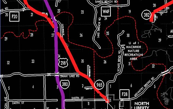
US 218 has been relocated from the Johnson‑Washington County
line north and northwest to an interchange with Interstate 80 and Interstate
380 in
PROPOSAL/ACTION
RECOMMENDATION:
It is
recommended to approve adding the description of
New
Description ‑
Coralville:
Beginning on
an unnamed street at a junction with US 6; thence north on unnamed street to
the north corporation line connecting with an unnamed street (south corporation
line of
Beginning at
the south corporation line (north corporation line of the City of
Beginning
again on the north corporation line of the City of
Beginning at
the south corporation line connecting with an unnamed street; thence northerly
to the north corporation line connecting with an unnamed street.
Beginning
again on the north corporation line of the City of North Liberty connecting
with an unnamed street; thence northerly following substantially the center
section line of Section 12‑T80N‑R7W to a point approximately 500
feet south of the N ¼ Corner Section 12‑T80N‑R7W; thence in a
northwesterly direction through Sections 12, 1, and 2‑T80N‑R7W and
Sections 35, 34, and 27‑T81N‑R7W to a point approximately 1300 feet
north and 1000 feet west of the SE Corner of Section 27‑T81N‑R7W;
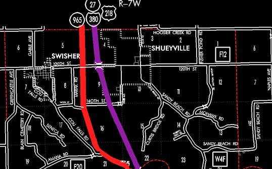
thence northwesterly through Sections 27, 22, 21, and 16‑T81N‑R7W
to a point near the NW Corner Section 16‑T81N‑R7W then northerly
following substantially the section line of Section 16, 9, and 4‑T81N‑R7W
to a point near the NW Corner Section 4‑T81N‑R7W, Johnson County
(SW Corner Section 33‑T82N‑R7W, Linn County).